Changeable and mixed - warmer and slightly wetter than average, but with the mean maximum only marginally above average
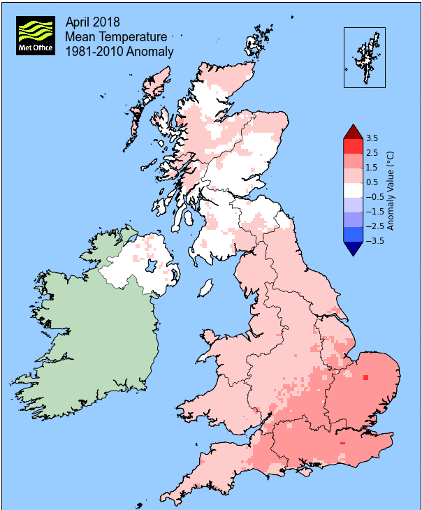
Quite a few people commented to me that April had been quite cold, so they may find it hard to believe that it was actually quite a bit warmer than average. It must be said that this is mainly due to the night-time minima been more than 1°c above average, with the day-time maximums much closer to, but still slightly above, average.
April started off cold and wet with a few flurries of snow/sleet up to the 4th and with low day-time maxima, a continuation of the theme from March. The first half of the month continued unsettled and generally cloudy and was often dull between the 6-17th, although marginally less cold, mainly at night. We had a brief warm spell from the 18th to the 21st, the latter attaining 20°c, but this warmer weather quickly disappeared with a spell of thunder! It then became progressively cooler through to the month's end with 'fresh and breezy' being a quite apt term and from the 27th we saw a return of frosts.
Maybe that perception of it being a cool month was due to the cold conditions at both ends of the month and with each spell being for a number of successive days; also coupled with sunshine totals being down on normal. Maybe it was just a typical April?
During the month, there were: two days with thunder and lightning (21st and 22nd), snow fell on three days (1st, 2nd and 4th) and hail fell on one day (29th).
MSLP of 1008.2 Mb was -5.5 Mb below the local average for April with pressure generally subdued and never rising that high (1023.3 MB at its highest).
Overall a mean minimum of 4.44°c and a mean maximum of 11.94°c saw the temperature 0.8°c above the 1981-2010 average. It was the warmest since 2014 and of the ten now recorded, six have been colder and three warmer. The highest maximum temperature recorded was 20°c (21st), the lowest minimum -2.2°c (5th).
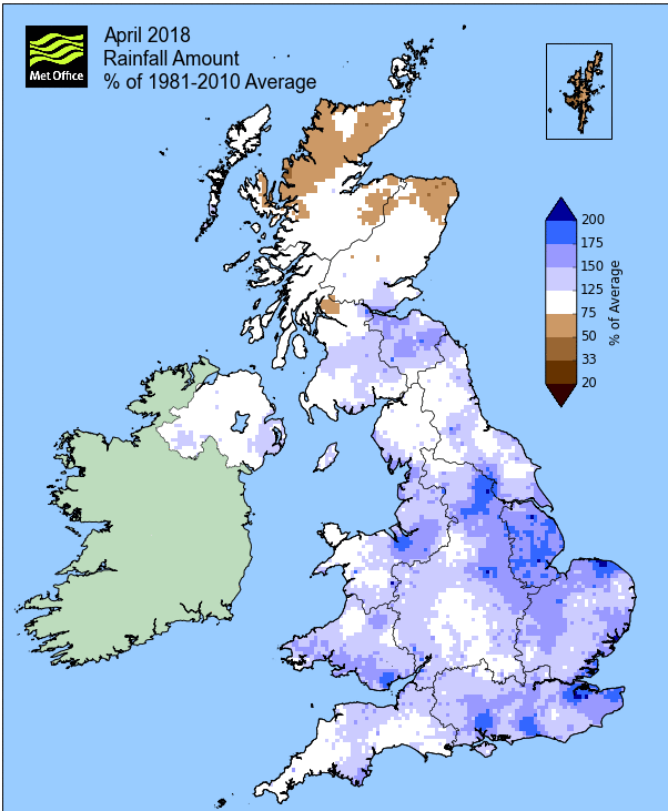
Rainfall of 63.7 mm (Crosby Ravensworth School 62.5 mm - Castlehowe Scar 95.1 mm - Reagill 56.1 mm) was 112.3% of average for 2008-17 and made it the wettest April since 2016. Of the eleven now recorded, seven have been drier and three have been wetter.
Winds may have been most prevalent from the SW, but nine days had winds from a SE-NE quadrant and will once again be the most likely reason as to why the rainfall was greater in Maulds Meaburn than Crosby Ravensworth this month.
At the Met' Office site at Newton Rigg, 53.2 mm (101.9%) made it the wettest April since 2016 and in a series back to 1900, April has been drier in 61 years and wetter in 57 years. A mean temperature of 8.1°c is the warmest since 2014 and in a series back to 1952 (1 yr of missing data), 53 have been colder, 11 have been warmer and 1 year had the same mean temperature.
Locally, rainfall percentages had a surprisingly wide variation as whilst rainfall was generally just above average (up to 110%), provisional figures show that just north and east of Penrith the average was down to 75%.
Figures from the Environment Agency�s rainfall sites were, (figure in brackets being the monthly average for 1961-90) �Data kindly provided by the Hydrometry and Telemetry team of the Environment Agency (Penrith)�:
Kirkby Thore 41.8 mm (55.4 mm)
Haresceugh Castle (Kirkoswald) 40.1 mm (53.0 mm)
Brothers Water 138.23 mm (129 mm) and
Orton (Shallowford) 82.4 mm (80.7 mm [average for 1967-2017])
??? mm at Seathwaite Farm (Borrowdale - 180 mm [average for 1981-2010]) - an inspection has discovered that the gauge was partially blocked. Totals for Feb', March and April will be re-calculated in due course.
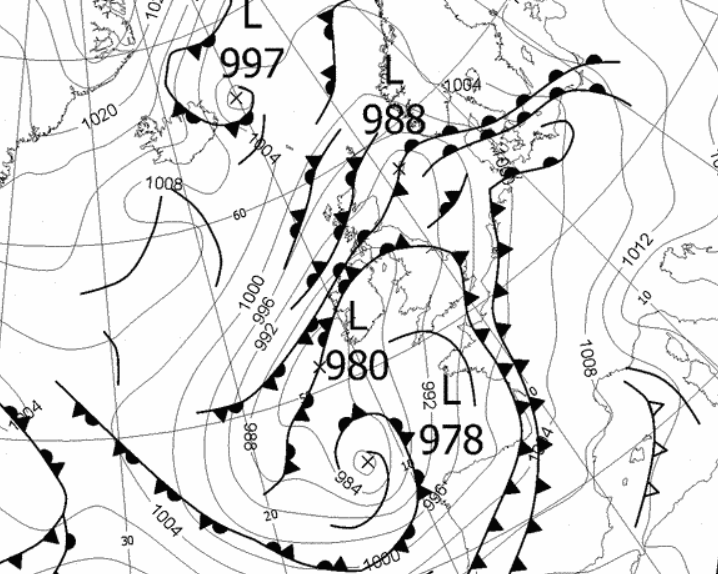
1st - 4th The month opened with a slack pressure gradient over the UK, replaced by low pressure (LP) up to the 4th during which time the temperature remained on the cool side with spells of rain.
Cool and cloudy on the 1st with a light snow shower during the morning, followed by a frontal system pushing up from the south on the 2nd that gave a poor day with sleet throughout (8.4 mm), turning to rain in the evening. The temperature during the day (Mn-Mn) would remain below 4°c, but would be recorded as 8.3°c, (a 24hr period of 10-1000 hrs being used), this being the temperature at 1000 hrs on the 3rd!
With the LP sitting in Biscay and the associated front only making slow progress north, both the 3rd (6.0 mm) and 4th (11.3 mm - month's wettest day) were equally poor days with rain frequent, falling as sleet in the evening of the 4th. The month had started wet and cool.
5th - 6th A ridge of high pressure (HP) nudging in from France finally brought a better day on the 5th, which after the months coldest night, -2.2°c (-28°f) did see plenty of sun.
The 6th saw the HP migrating east, but managing to hold at bay a LP system that was approaching from the Atlantic; the day being dry if cloudy.
7th The area of LP finally replaced the HP and would sit over the south of the UK. This gave another poor day for the 7th with rain (7.4 mm) throughout and becoming quite murky.
8th - 9th It was back to a weak ridge of HP and two reasonable days, especially the 9th.
A warm front in the southern part of the UK became fairly static in a line SW down from The Wash and whilst the 8th was generally cloudy, the 9th was a fine sunny day and with the temperature rising to 15.6°c it did feel like spring.
Late on the 9th that warm front suddenly ventured north, bringing a spell of light rain.
10th - 14th The next few days became plagued with misty, grey and very dull conditions and was all a little bit the same and really a little grim, albeit the daffodils did finally bloom on the 10th!
HP over Norway and LP to the south resulted in an E'ly flow that had its origins over mainland Europe (not Siberia); this was not a 'beast'. Rainfall wasn't that frequent or heavy, confined to a little at tea-time 12th, then overnight into the 13th with drizzle in the morning.
Apart from the murk, but partly because off, it was quite cool, down to 8.1°c on the 12th, but the murkiest day would be the 13th as the pressure gradient slackened out but with LP centred over Cumbria.
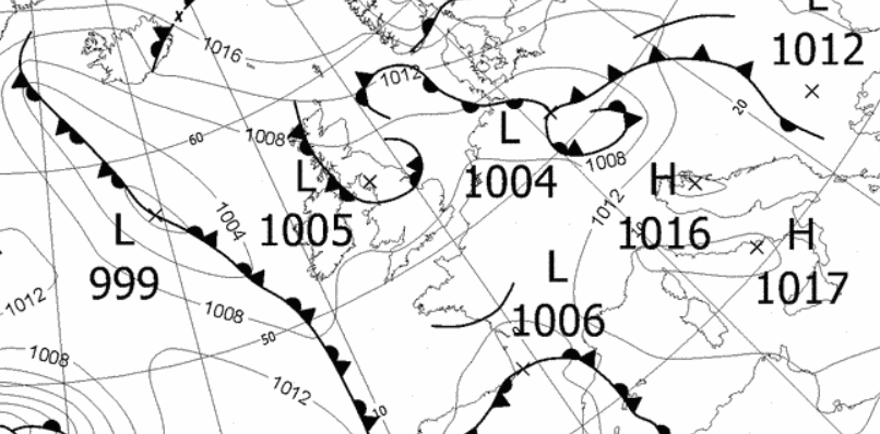 1200 Hrs 13th - slack pressure, nominal easterly - murk
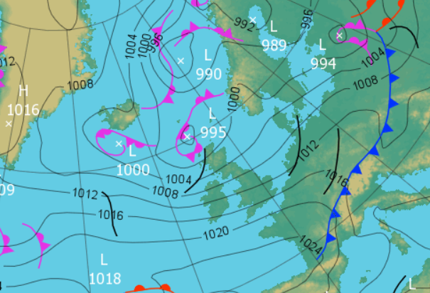
15th - 18th LP in the Atlantic was making steady progress towards the UK and arrived during the evening of the 15th. Whilst we had periods of rain overnight into the 16th, it wasn't that heavy (4.7 mm) and after some drizzle first thing on the 16th, it became a cloudy and breezy day.
A mild period of weather would then follow. Another area of LP in the Atlantic would be held at bay by HP over Europe resulting in a very mild southerly air flow, which would see the temperature rise noticeably and quickly, 12-13°c (16-17th) would become 18-19° (18-19th) overnight.
A warm front associated to that LP would move S-N over the UK during the 18th and as it cleared north it allowed HP over Germany to move in over the UK and which would maintain the southerly flow.
Despite the presence of fronts over or near the UK, the sun came out during the 18th and stayed that way for the next few days. Whilst it had been mild by both day and night, the 20th was slightly cooler as a weak cold front moved east across the country and with clearer skies behind the 21st started much cooler than of late.
The 21st itself would be a fine sunny day and also warm. Behind that cold front HP built and moved over the UK and still with the nominal S'ly the temperature rose to a month's high of 20°c (68°f). The front of the previous day, but now a weak warm front would return, and with LP in the Atlantic pushing cold fronts towards the UK, the inevitable breakdown soon arrived.
The thunder arrived at 9 p.m. and with it some quite vivid lightning. However, and despite more thunder overnight, there wasn't any great storm to accompany it and the rainfall would only total 5.0 mm.
Now into the tenth year of temperature records, 20°c is, on average, attained on the 4th May, so at least in this respect, 2018 is ahead of schedule. Three of the other nine years has seen 20°c arrive earlier.
22nd - 30th Fresh, breezy and much cooler conditions then persisted through to the end of the month. Initially on a WSW'ly airflow which originated from Greenland and then on a cooler ENE'ly from the 28th, with a number of nights having ground frosts.
The day-time temperatures fell as quickly as it had risen. From the 20°c of the 21st, it was down to 11.7°c on the 22nd and would get no higher. A succession of LP systems would push fronts towards the UK on that WSW'ly, but despite this, rainfall was infrequent and totals light and indeed there were some decent sunny spells - all fairly typical for April, but 'fresh and breezy' was most apt.
The change in wind direction later in the period had the effect of turning the temperature down another notch, more so by night. A small, but vigorous LP system moved SW-NE across the southern half of the UK, fortunately not venturing far enough north to bother us with its rain, but as it exited out into the North Sea it resulted in drawing in winds from an ENE'ly direction.
The northern part of England and the UK remained in a relative slack pressure gradient, so the ENE'ly was generally light, but even so, it could be felt. The days tended to follow a similar pattern of generally cloudy for most of the day with the sun coming out late in the afternoon. With light winds and the cloud dissipating sufficiently, the nights became noticeably cooler and ground frosts were recorded every night from the 27th. The 28th also saw a marginal air frost, before the month would end on an even chillier note.
During the evening of the 29th the skies totally cleared of any cloud and the temperature dropped away quickly, the 30th starting with an air frost of -0.8°c, albeit the day would see plenty of sun and possibly felt better than a high of 11.2°c.
Rainfall totalled 63.7 mm for the month, with rain recorded on 17 days of which 15 were 'Wet days' (1.0mm +).
The Mean Temperature for the month was 8.19°c -- The Mean Max' was 11.94°c -- The Mean Min' 4.44°c.
We had 3 Air Frosts in the month (year 45) -- Grass frosts totalled 9 (year 69).
The 1 foot soil temp ranged from a low of 5.8°c on the 1st - 3rd to a high of 11.8°c on the 22nd -- with a monthly mean of 8.8°c
The 1 meter soil temp ranged from a low of 6.0°c on the 2nd + 4th to a high of 8.8°c on the 25th-30th -- with a monthly mean of 7.4°c
COMPARISONS:-
* April 2018 rainfall was 112.3% of the April average for 2008 - 2017
* April 2018 was 0.42°c warmer than the April average for 2009 - 2017 and 0.8°c warmer than the local long term average 1981-2010
* This makes the Jan' to April period of 2018 0.65°c colder than the average for 2009-17 and with 95.8% of average rainfall for 2008-17
JANUARY 2010
FEBRUARY 2010
MARCH 2010
APRIL 2010
MAY 2010
JUNE 2010
JULY 2010
AUGUST 2010
SEPTEMBER 2010
OCTOBER 2010
NOVEMBER 2010
DECEMBER 2010
JANUARY 2011
FEBRUARY 2011
MARCH 2011
APRIL 2011
MAY 2011
JUNE 2011
JULY 2011
AUGUST 2011
SEPTEMBER 2011
OCTOBER 2011
NOVEMBER 2011
DECEMBER 2011
JANUARY 2012
FEBRUARY 2012
MARCH 2012
APRIL 2012
MAY 2012
JUNE 2012
JULY 2012
AUGUST 2012
SEPTEMBER 2012
OCTOBER 2012
NOVEMBER 2012
DECEMBER 2012
SUMMER 2012
REVIEW OF 2012
JANUARY 2013
FEBRUARY 2013
MARCH 2013
APRIL 2013
MAY 2013
JUNE 2013
JULY 2013
AUGUST 2013
SEPTEMBER 2013
OCTOBER 2013
NOVEMBER 2013
DECEMBER 2013
REVIEW OF 2013
JANUARY 2014
FEBRUARY 2014
MARCH 2014
APRIL 2014
MAY 2014
JUNE 2014
JULY 2014
AUGUST 2014
SEPTEMBER 2014
OCTOBER 2014
NOVEMBER 2014
DECEMBER 2014
WINTER 2014
REVIEW OF 2014
JANUARY 2015
FEBRUARY 2015
MARCH 2015
APRIL 2015
MAY 2015
JUNE 2015
JULY 2015
AUGUST 2015
SEPTEMBER 2015
OCTOBER 2015
NOVEMBER 2015
DECEMBER 2015
REVIEW OF 2015
JANUARY 2016
FEBRUARY 2016
MARCH 2016
APRIL 2016
MAY 2016
JUNE 2016
JULY 2016
AUGUST 2016
SEPTEMBER 2016
OCTOBER 2016
NOVEMBER 2016
DECEMBER 2016
REVIEW OF 2016
JANUARY 2017
FEBRUARY 2017
MARCH 2017
APRIL 2017
MAY 2017
JUNE 2017
JULY 2017
AUGUST 2017
SEPTEMBER 2017
OCTOBER 2017
NOVEMBER 2017
DECEMBER 2017
REVIEW OF 2017
JANUARY 2018
FEBRUARY 2018
MARCH 2018
OTHER ARTICLES
The Oldest Inhabitant
An Inch Of Scotch Mist
But it's meant to be Summer (Summer 2017)
© Darren Rogers 2010-18
Want to comment on this site? email